| | QmapShack une alternative à Basecamp |    |
|
|
| Auteur | Message |
|---|
Romurider31
Pilier du forum


MOTOS : KTM 790 ADVENTURE R, KTM 450 EXC, KTM 250 R FREERIDE
Messages : 514
Date d'inscription : 20/11/2022
Age : 50
Ville ou région : Bessières 31660 Occitanie
 |  Sujet: Re: QmapShack une alternative à Basecamp Sujet: Re: QmapShack une alternative à Basecamp  Mar 20 Déc 2022 - 16:32 Mar 20 Déc 2022 - 16:32 | |
| Bonjour CRICRI,
J'ai commencer la progression d'installation et utilisation de basecamp et je me retrouve arrêté pour télécharger les cartes de mon bureau a basecamp.
Je les ai bien téléchargés a partir de tes liens sur le bureau de mon ordi mais le copier glisser ne fonctionne pas vers BASECAMP
Merci de ton aide |
|
  | |
Invité
Invité

 |  Sujet: Re: QmapShack une alternative à Basecamp Sujet: Re: QmapShack une alternative à Basecamp  Mar 20 Déc 2022 - 17:14 Mar 20 Déc 2022 - 17:14 | |
| - Romurider31 a écrit:
- Bonjour CRICRI,
J'ai commencer la progression d'installation et utilisation de basecamp et je me retrouve arrêté pour télécharger les cartes de mon bureau a basecamp.
Je les ai bien téléchargés a partir de tes liens sur le bureau de mon ordi mais le copier glisser ne fonctionne pas vers BASECAMP
Merci de ton aide et oui Basecamp c'est un peu "sioux"  merci aux applis "propriétaires" :( en fait "mes" cartes doivent être copiées dans ton GPS pour être lues/utilisées dans basecamp historiquement c'est le moyen de diffusion par garmin des cartes qu'il vend pour ses gps avantage: c'est hyper simple inconvénient: faut brancher le gps à chaque fois et c'est assez lent du coup il faut "tricher" en créant une carte SD virtuelle dans ton windows qui sera aussi rapide que si tu lisais la carte depuis la mémoire RAM de ton PC et mettre les cartes dedans. la création a déjà ete abordée sur le forum, y'a differentes techniques pour le faire. |
|
  | |
Romurider31
Pilier du forum


MOTOS : KTM 790 ADVENTURE R, KTM 450 EXC, KTM 250 R FREERIDE
Messages : 514
Date d'inscription : 20/11/2022
Age : 50
Ville ou région : Bessières 31660 Occitanie
 |  Sujet: Re: QmapShack une alternative à Basecamp Sujet: Re: QmapShack une alternative à Basecamp  Mar 20 Déc 2022 - 18:18 Mar 20 Déc 2022 - 18:18 | |
| Salut Cricri,
Je n'utilise pas de GPS juste OSMAND sur ma tablette DURCI ou mon Navigattor du coup pas le choix d'essayer ta parade de triche ? |
|
  | |
Invité
Invité

 |  Sujet: Re: QmapShack une alternative à Basecamp Sujet: Re: QmapShack une alternative à Basecamp  Mar 20 Déc 2022 - 18:51 Mar 20 Déc 2022 - 18:51 | |
| oui, c'est assez "simple", tu installes "ImDisk Virtual Disk Driver" tu crées ta SD virtuelle > un fichier *.vg sur ton disque le plus rapide en ssd pour ne pas prendre de la RAM inutilement, si pas de SSD tu le fais en RAM > tu le configure pour être "removable device" et basecamp n'y verra que du feu et pensera que c'est un GPS. sinon tu cherches comment on transforme "mes" cartes en "mapset" garmin et tu les installe sur ton disque ;) (via GmapTool par exemple) j'espère que tu es geek, quand tu mets un doigt dans l'univers Garmin (dont fait parti Basecamp) et que tu ne veux pas utiliser les produits Garmin inutilement cher et limité, tu as vite fait de voir passer l'hiver sans t'en rendre compte  |
|
  | |
Romurider31
Pilier du forum


MOTOS : KTM 790 ADVENTURE R, KTM 450 EXC, KTM 250 R FREERIDE
Messages : 514
Date d'inscription : 20/11/2022
Age : 50
Ville ou région : Bessières 31660 Occitanie
 |  Sujet: Re: QmapShack une alternative à Basecamp Sujet: Re: QmapShack une alternative à Basecamp  Mer 21 Déc 2022 - 13:37 Mer 21 Déc 2022 - 13:37 | |
| Cricri, Merci beaucoup pour ce complément d'information. J'ai pu commencer à étudier la création d'itinéraire à partir de ton TUTO et ce qui m'interpelle c'est que chaque trace est créé justement a partir de la création d'un itinéraire ! Est ce que tu aurais le même genre de TUTO en boutique pour la création direct manuellement d'un sur la carte sans passer par la création d'un itinéraire puis conversion   J'ai l'impression que ce mode permet de passer direct la ou on souhaite |
|
  | |
Invité
Invité

 |  Sujet: Re: QmapShack une alternative à Basecamp Sujet: Re: QmapShack une alternative à Basecamp  Mer 21 Déc 2022 - 17:32 Mer 21 Déc 2022 - 17:32 | |
| oui c'est ce qu'on (je) faisait avant, tu "dessines" sur la carte en mode vol d'oiseau > quand c'est long ... bon courage  autant aller sur un site web dédié qui affiche l'IGN et dessiner dessus. moi j'utilise le traçage d'itinéraire pour pas passer 3h à dessiner les sentiers ;) en plus la trace correspond pil poil à la carto dans le GPS/tél ensuite je l'utilise en trace parce que le guidage me gonfle et me perturbe plus qu'autre chose. mais oui c'est possible bien sur. |
|
  | |
Romurider31
Pilier du forum


MOTOS : KTM 790 ADVENTURE R, KTM 450 EXC, KTM 250 R FREERIDE
Messages : 514
Date d'inscription : 20/11/2022
Age : 50
Ville ou région : Bessières 31660 Occitanie
 |  Sujet: Re: QmapShack une alternative à Basecamp Sujet: Re: QmapShack une alternative à Basecamp  Mer 21 Déc 2022 - 21:36 Mer 21 Déc 2022 - 21:36 | |
| - cricri a écrit:
- oui c'est ce qu'on (je) faisait avant, tu "dessines" sur la carte en mode vol d'oiseau > quand c'est long ... bon courage

autant aller sur un site web dédié qui affiche l'IGN et dessiner dessus.
moi j'utilise le traçage d'itinéraire pour pas passer 3h à dessiner les sentiers ;)
en plus la trace correspond pil poil à la carto dans le GPS/tél
ensuite je l'utilise en trace parce que le guidage me gonfle et me perturbe plus qu'autre chose.
mais oui c'est possible bien sur. Je vais suivre tes conseil et m'assayer en posant les points de toute manière j'imagine que si ont pose les points sur des sentier ou piste il les reliera entre eux en les maintenant sur ces mêmes pistes ou sentiers |
|
  | |
Invité
Invité

 |  Sujet: Re: QmapShack une alternative à Basecamp Sujet: Re: QmapShack une alternative à Basecamp  Mer 21 Déc 2022 - 21:46 Mer 21 Déc 2022 - 21:46 | |
| - cricri a écrit:
- .........................
sinon tu cherches comment on transforme "mes" cartes en "mapset" garmin et tu les installe sur ton disque ;) (via GmapTool par exemple)
............................. https://sites.google.com/site/scdiscdi/Home/mapsource?pli=1 Voir tuto N°2. C'est possible des que le fichier ".img" est sur le disque dur Cricri est astucieux. Il crée un itinéraire en quelques minutes et ensuite le transforme en trace. Le second avantage est que la trace est parfaitement sur le chemin.  |
|
  | |
Romurider31
Pilier du forum


MOTOS : KTM 790 ADVENTURE R, KTM 450 EXC, KTM 250 R FREERIDE
Messages : 514
Date d'inscription : 20/11/2022
Age : 50
Ville ou région : Bessières 31660 Occitanie
 |  Sujet: Re: QmapShack une alternative à Basecamp Sujet: Re: QmapShack une alternative à Basecamp  Mer 21 Déc 2022 - 21:55 Mer 21 Déc 2022 - 21:55 | |
| Merci  |
|
  | |
Romurider31
Pilier du forum


MOTOS : KTM 790 ADVENTURE R, KTM 450 EXC, KTM 250 R FREERIDE
Messages : 514
Date d'inscription : 20/11/2022
Age : 50
Ville ou région : Bessières 31660 Occitanie
 |  Sujet: Re: QmapShack une alternative à Basecamp Sujet: Re: QmapShack une alternative à Basecamp  Mar 3 Jan 2023 - 17:11 Mar 3 Jan 2023 - 17:11 | |
| Messieurs Rois de BASECAMP pouvez vous me dire si il est possible de l'installer sur ANDROID (ma tablette SAMSUNG ACTIVE 2) qui me sert de navigation sur OSMAND et de travailler directement sur BASCAMP sur ma tablette |
|
  | |
EDN
Membre Super VIP

MOTOS : 400 XR - 1000 CRF - 125 XL - 501 FE
Messages : 1730
Date d'inscription : 30/10/2015
Age : 61
Ville ou région : PUJAUDRAN
 |  Sujet: Re: QmapShack une alternative à Basecamp Sujet: Re: QmapShack une alternative à Basecamp  Mar 3 Jan 2023 - 17:14 Mar 3 Jan 2023 - 17:14 | |
| - Romurider31 a écrit:
- Messieurs Rois de BASECAMP pouvez vous me dire si il est possible de l'installer sur ANDROID (ma tablette SAMSUNG ACTIVE 2) qui me sert de navigation sur OSMAND et de travailler directement sur BASCAMP sur ma tablette
Pas possible je pense. _________________ Eric 2 XR au Maroc Maroc 2006 - Maroc 2008 - Algérie 2009 - Viet Nam 2013 - Maroc 2018 |
|
  | |
leroudani
Pilier du forum

MOTOS : TTR250 PR7AJP
Messages : 783
Date d'inscription : 15/05/2020
Age : 70
Ville ou région : 34
 |  Sujet: Re: QmapShack une alternative à Basecamp Sujet: Re: QmapShack une alternative à Basecamp  Mar 3 Jan 2023 - 19:44 Mar 3 Jan 2023 - 19:44 | |
| - Romurider31 a écrit:
- Messieurs Rois de BASECAMP pouvez vous me dire si il est possible de l'installer sur ANDROID (ma tablette SAMSUNG ACTIVE 2) qui me sert de navigation sur OSMAND et de travailler directement sur BASCAMP sur ma tablette
Hélas non ! Mais je ne suis pas plus roi que toi, et si je me trompe j'en serais ravi ... |
|
  | |
jerome01
Membre - Super Actif


MOTOS : bmw1200gsa 450wrf
Pneu AV/AR : Motoz tracker pour wrf, scorpions pour GSA
Messages : 343
Date d'inscription : 08/02/2017
Age : 61
Ville ou région : Ambérieu 01
 |  Sujet: Carte IGN sur Qmapshack versions de juillet 2023 sur serveurs béta Sujet: Carte IGN sur Qmapshack versions de juillet 2023 sur serveurs béta  Mar 11 Juil 2023 - 10:00 Mar 11 Juil 2023 - 10:00 | |
| Suite à la migration des serveurs de l'IGN, le renouvellement de mes clés géoportail ne peut se faire. J'ai donc migré mes cartes IGN. Voici le version TMS sans code d'accès que j'ai ajusté avec les serveurs Béta, c'est libre désormais: - Code:
-
<TMS>
<Layer idx="0">
<Title>PLAN-IGN_PNG</Title>
<MinZoomLevel>0</MinZoomLevel>
<MaxZoomLevel>19</MaxZoomLevel>
<ServerUrl>https://wmts.geopf.fr/rok4/tms/1.0.0/PLAN-IGN_PNG/%1/%2/%3.png</ServerUrl>
</Layer>
<Copyright> :copyright: IGN – 2022 – Copie et reproduction interdite</Copyright>
</TMS> et la version WMTS: - Code:
-
<?xml version="1.0" encoding="UTF-8"?>
<Capabilities
xmlns="http://www.opengis.net/wmts/1.0"
xmlns:gml="http://www.opengis.net/gml"
xmlns:ows="http://www.opengis.net/ows/1.1"
xmlns:xlink="http://www.w3.org/1999/xlink"
xmlns:xsi="http://www.w3.org/2001/XMLSchema-instance" version="1.0.0" xsi:schemaLocation="http://www.opengis.net/wmts/1.0 http://schemas.opengis.net/wmts/1.0/wmtsGetCapabilities_response.xsd">
<ows:ServiceIdentification>
<ows:Title>Service de visualisation WMTS</ows:Title>
<ows:Abstract>Ce service permet la visualisation de couches de données raster IGN au travers d'un flux WMTS</ows:Abstract>
<ows:Keywords>
<ows:Keyword>Unites administratives</ows:Keyword>
<ows:Keyword>Limites administratives</ows:Keyword>
<ows:Keyword>Surfaces bâties</ows:Keyword>
<ows:Keyword>Réseaux de transport</ows:Keyword>
<ows:Keyword>Routes</ows:Keyword>
<ows:Keyword>Réseaux ferroviaires</ows:Keyword>
<ows:Keyword>Aérodromes</ows:Keyword>
<ows:Keyword>Réseau hydrographique</ows:Keyword>
<ows:Keyword>Parcelles cadastrales</ows:Keyword>
<ows:Keyword>Bâtiments</ows:Keyword>
<ows:Keyword>Services d'utilité publique et services publics</ows:Keyword>
<ows:Keyword>Réseaux de transport</ows:Keyword>
<ows:Keyword>Hydrographie</ows:Keyword>
<ows:Keyword>Photographies aériennes</ows:Keyword>
<ows:Keyword>Cartes</ows:Keyword>
<ows:Keyword>Cartes historiques</ows:Keyword>
<ows:Keyword>Altitude</ows:Keyword>
</ows:Keywords>
<ows:ServiceType>OGC WMTS</ows:ServiceType>
<ows:ServiceTypeVersion>1.0.0</ows:ServiceTypeVersion>
<ows:Fees>licences</ows:Fees>
<ows:AccessConstraints>Conditions Générales d'Utilisation disponibles ici : http://professionnels.ign.fr/doc/Conditions_d_utilisation_des_licences_et_des_services_en_ligne.pdf</ows:AccessConstraints>
</ows:ServiceIdentification>
<ows:ServiceProvider>
<ows:ProviderName>IGN</ows:ProviderName>
<ows:ProviderSite xlink:href=""/>
<ows:ServiceContact>
<ows:IndividualName>Géoportail SAV</ows:IndividualName>
<ows:PositionName>custodian</ows:PositionName>
<ows:ContactInfo>
<ows:Phone>
<ows:Voice/>
<ows:Facsimile/>
</ows:Phone>
<ows:Address>
<ows:DeliveryPoint>73 avenue de Paris</ows:DeliveryPoint>
<ows:City>Saint Mandé</ows:City>
<ows:AdministrativeArea/>
<ows:PostalCode>94160</ows:PostalCode>
<ows:Country>France</ows:Country>
<ows:ElectronicMailAddress>geop_services@geoportail.fr</ows:ElectronicMailAddress>
</ows:Address>
</ows:ContactInfo>
</ows:ServiceContact>
</ows:ServiceProvider>
<ows:OperationsMetadata>
<ows:Operation name="GetCapabilities">
<ows:DCP>
<ows:HTTP>
<ows:Get xlink:href="https://wmts.geopf.fr/rok4/wmts?SERVICE=WMTS&VERSION=1.0.0&REQUEST=GetCapabilities">
<ows:Constraint name="GetEncoding">
<ows:AllowedValues>
<ows:Value>KVP</ows:Value>
</ows:AllowedValues>
</ows:Constraint>
</ows:Get>
</ows:HTTP>
</ows:DCP>
</ows:Operation>
<ows:Operation name="GetTile">
<ows:DCP>
<ows:HTTP>
<ows:Get xlink:href="https://wmts.geopf.fr/rok4/wmts?SERVICE=WMTS&VERSION=1.0.0&REQUEST=GetTile">
<ows:Constraint name="GetEncoding">
<ows:AllowedValues>
<ows:Value>KVP</ows:Value>
</ows:AllowedValues>
</ows:Constraint>
</ows:Get>
</ows:HTTP>
</ows:DCP>
</ows:Operation>
<ows:Operation name="GetFeatureInfo">
<ows:DCP>
<ows:HTTP>
<ows:Get xlink:href="https://wmts.geopf.fr/rok4/wmts?SERVICE=WMTS&VERSION=1.0.0&REQUEST=GetFeatureInfo">
<ows:Constraint name="GetEncoding">
<ows:AllowedValues>
<ows:Value>KVP</ows:Value>
</ows:AllowedValues>
</ows:Constraint>
</ows:Get>
</ows:HTTP>
</ows:DCP>
</ows:Operation>
</ows:OperationsMetadata>
<Contents>
<Layer>
<ows:Title>Cartes IGN</ows:Title>
<ows:Abstract>Cartes IGN</ows:Abstract>
<ows:Keywords>
<ows:Keyword>Cartes</ows:Keyword>
</ows:Keywords>
<ows:WGS84BoundingBox>
<ows:LowerCorner>-180 -68.1389</ows:LowerCorner>
<ows:UpperCorner>180 80</ows:UpperCorner>
</ows:WGS84BoundingBox>
<ows:Identifier>PLAN-IGN_PNG</ows:Identifier>
<Style isDefault="true">
<ows:Title>Légende générique</ows:Title>
<ows:Abstract>Fichier de légende générique – pour la compatibilité avec certains systèmes</ows:Abstract>
<ows:Keywords>
<ows:Keyword>Défaut</ows:Keyword>
</ows:Keywords>
<ows:Identifier>normal</ows:Identifier>
<LegendURL format="image/jpeg" height="200" maxScaleDenominator="100000000" minScaleDenominator="200" width="200" xlink:href="http://wxs.ign.fr/static/legends/LEGEND.jpg"/>
</Style>
<Format>image/png</Format>
<TileMatrixSetLink>
<TileMatrixSet>PM</TileMatrixSet>
<TileMatrixSetLimits>
<TileMatrixLimits>
<TileMatrix>0</TileMatrix>
<MinTileRow>0</MinTileRow>
<MaxTileRow>0</MaxTileRow>
<MinTileCol>0</MinTileCol>
<MaxTileCol>1</MaxTileCol>
</TileMatrixLimits>
<TileMatrixLimits>
<TileMatrix>1</TileMatrix>
<MinTileRow>0</MinTileRow>
<MaxTileRow>1</MaxTileRow>
<MinTileCol>0</MinTileCol>
<MaxTileCol>2</MaxTileCol>
</TileMatrixLimits>
<TileMatrixLimits>
<TileMatrix>10</TileMatrix>
<MinTileRow>340</MinTileRow>
<MaxTileRow>780</MaxTileRow>
<MinTileCol>5</MinTileCol>
<MaxTileCol>990</MaxTileCol>
</TileMatrixLimits>
<TileMatrixLimits>
<TileMatrix>11</TileMatrix>
<MinTileRow>681</MinTileRow>
<MaxTileRow>1544</MaxTileRow>
<MinTileCol>10</MinTileCol>
<MaxTileCol>1981</MaxTileCol>
</TileMatrixLimits>
<TileMatrixLimits>
<TileMatrix>12</TileMatrix>
<MinTileRow>1363</MinTileRow>
<MaxTileRow>3088</MaxTileRow>
<MinTileCol>20</MinTileCol>
<MaxTileCol>3962</MaxTileCol>
</TileMatrixLimits>
<TileMatrixLimits>
<TileMatrix>13</TileMatrix>
<MinTileRow>2726</MinTileRow>
<MaxTileRow>6177</MaxTileRow>
<MinTileCol>40</MinTileCol>
<MaxTileCol>7924</MaxTileCol>
</TileMatrixLimits>
<TileMatrixLimits>
<TileMatrix>14</TileMatrix>
<MinTileRow>5452</MinTileRow>
<MaxTileRow>12355</MaxTileRow>
<MinTileCol>81</MinTileCol>
<MaxTileCol>15847</MaxTileCol>
</TileMatrixLimits>
<TileMatrixLimits>
<TileMatrix>15</TileMatrix>
<MinTileRow>10944</MinTileRow>
<MaxTileRow>21176</MaxTileRow>
<MinTileCol>163</MinTileCol>
<MaxTileCol>31695</MaxTileCol>
</TileMatrixLimits>
<TileMatrixLimits>
<TileMatrix>16</TileMatrix>
<MinTileRow>21889</MinTileRow>
<MaxTileRow>42353</MaxTileRow>
<MinTileCol>326</MinTileCol>
<MaxTileCol>63382</MaxTileCol>
</TileMatrixLimits>
<TileMatrixLimits>
<TileMatrix>17</TileMatrix>
<MinTileRow>43776</MinTileRow>
<MaxTileRow>73526</MaxTileRow>
<MinTileCol>42528</MinTileCol>
<MaxTileCol>85869</MaxTileCol>
</TileMatrixLimits>
<TileMatrixLimits>
<TileMatrix>18</TileMatrix>
<MinTileRow>87557</MinTileRow>
<MaxTileRow>147052</MaxTileRow>
<MinTileCol>85058</MinTileCol>
<MaxTileCol>171738</MaxTileCol>
</TileMatrixLimits>
<TileMatrixLimits>
<TileMatrix>2</TileMatrix>
<MinTileRow>0</MinTileRow>
<MaxTileRow>2</MaxTileRow>
<MinTileCol>0</MinTileCol>
<MaxTileCol>4</MaxTileCol>
</TileMatrixLimits>
<TileMatrixLimits>
<TileMatrix>3</TileMatrix>
<MinTileRow>0</MinTileRow>
<MaxTileRow>5</MaxTileRow>
<MinTileCol>0</MinTileCol>
<MaxTileCol>8</MaxTileCol>
</TileMatrixLimits>
<TileMatrixLimits>
<TileMatrix>4</TileMatrix>
<MinTileRow>1</MinTileRow>
<MaxTileRow>11</MaxTileRow>
<MinTileCol>0</MinTileCol>
<MaxTileCol>16</MaxTileCol>
</TileMatrixLimits>
<TileMatrixLimits>
<TileMatrix>5</TileMatrix>
<MinTileRow>3</MinTileRow>
<MaxTileRow>22</MaxTileRow>
<MinTileCol>0</MinTileCol>
<MaxTileCol>32</MaxTileCol>
</TileMatrixLimits>
<TileMatrixLimits>
<TileMatrix>6</TileMatrix>
<MinTileRow>7</MinTileRow>
<MaxTileRow>45</MaxTileRow>
<MinTileCol>0</MinTileCol>
<MaxTileCol>64</MaxTileCol>
</TileMatrixLimits>
<TileMatrixLimits>
<TileMatrix>7</TileMatrix>
<MinTileRow>42</MinTileRow>
<MaxTileRow>97</MaxTileRow>
<MinTileCol>0</MinTileCol>
<MaxTileCol>115</MaxTileCol>
</TileMatrixLimits>
<TileMatrixLimits>
<TileMatrix>8</TileMatrix>
<MinTileRow>84</MinTileRow>
<MaxTileRow>195</MaxTileRow>
<MinTileCol>1</MinTileCol>
<MaxTileCol>247</MaxTileCol>
</TileMatrixLimits>
<TileMatrixLimits>
<TileMatrix>9</TileMatrix>
<MinTileRow>170</MinTileRow>
<MaxTileRow>390</MaxTileRow>
<MinTileCol>2</MinTileCol>
<MaxTileCol>495</MaxTileCol>
</TileMatrixLimits>
</TileMatrixSetLimits>
</TileMatrixSetLink>
<ResourceURL format="image/png" resourceType="tile" template="https://wmts.geopf.fr/rok4/wmts?SERVICE=WMTS&REQUEST=GetTile&LAYER=PLAN-IGN_PNG&EXCEPTIONS=text/xml&FORMAT=image/png&SERVICE=WMTS&VERSION=1.0.0&REQUEST=GetTile&STYLE=inspire&TILEMATRIXSET={TileMatrixSet}&TILEMATRIX={TileMatrix}&TILECOL={TileCol}&TILEROW={TileRow}"/>
</Layer>
<TileMatrixSet>
<ows:Identifier>PM</ows:Identifier>
<ows:SupportedCRS>EPSG:3857</ows:SupportedCRS>
<TileMatrix>
<ows:Identifier>0</ows:Identifier>
<ScaleDenominator>559082264.0287178958533332</ScaleDenominator>
<TopLeftCorner>-20037508 20037508</TopLeftCorner>
<TileWidth>256</TileWidth>
<TileHeight>256</TileHeight>
<MatrixWidth>1</MatrixWidth>
<MatrixHeight>1</MatrixHeight>
</TileMatrix>
<TileMatrix>
<ows:Identifier>1</ows:Identifier>
<ScaleDenominator>279541132.0143588959472254</ScaleDenominator>
<TopLeftCorner>-20037508 20037508</TopLeftCorner>
<TileWidth>256</TileWidth>
<TileHeight>256</TileHeight>
<MatrixWidth>2</MatrixWidth>
<MatrixHeight>2</MatrixHeight>
</TileMatrix>
<TileMatrix>
<ows:Identifier>10</ows:Identifier>
<ScaleDenominator>545978.7734655447186469</ScaleDenominator>
<TopLeftCorner>-20037508 20037508</TopLeftCorner>
<TileWidth>256</TileWidth>
<TileHeight>256</TileHeight>
<MatrixWidth>1024</MatrixWidth>
<MatrixHeight>1024</MatrixHeight>
</TileMatrix>
<TileMatrix>
<ows:Identifier>11</ows:Identifier>
<ScaleDenominator>272989.3867327723085907</ScaleDenominator>
<TopLeftCorner>-20037508 20037508</TopLeftCorner>
<TileWidth>256</TileWidth>
<TileHeight>256</TileHeight>
<MatrixWidth>2048</MatrixWidth>
<MatrixHeight>2048</MatrixHeight>
</TileMatrix>
<TileMatrix>
<ows:Identifier>12</ows:Identifier>
<ScaleDenominator>136494.6933663861796617</ScaleDenominator>
<TopLeftCorner>-20037508 20037508</TopLeftCorner>
<TileWidth>256</TileWidth>
<TileHeight>256</TileHeight>
<MatrixWidth>4096</MatrixWidth>
<MatrixHeight>4096</MatrixHeight>
</TileMatrix>
<TileMatrix>
<ows:Identifier>13</ows:Identifier>
<ScaleDenominator>68247.3466831930771477</ScaleDenominator>
<TopLeftCorner>-20037508 20037508</TopLeftCorner>
<TileWidth>256</TileWidth>
<TileHeight>256</TileHeight>
<MatrixWidth>8192</MatrixWidth>
<MatrixHeight>8192</MatrixHeight>
</TileMatrix>
<TileMatrix>
<ows:Identifier>14</ows:Identifier>
<ScaleDenominator>34123.6733415965449154</ScaleDenominator>
<TopLeftCorner>-20037508 20037508</TopLeftCorner>
<TileWidth>256</TileWidth>
<TileHeight>256</TileHeight>
<MatrixWidth>16384</MatrixWidth>
<MatrixHeight>16384</MatrixHeight>
</TileMatrix>
<TileMatrix>
<ows:Identifier>15</ows:Identifier>
<ScaleDenominator>17061.8366707982724577</ScaleDenominator>
<TopLeftCorner>-20037508 20037508</TopLeftCorner>
<TileWidth>256</TileWidth>
<TileHeight>256</TileHeight>
<MatrixWidth>32768</MatrixWidth>
<MatrixHeight>32768</MatrixHeight>
</TileMatrix>
<TileMatrix>
<ows:Identifier>16</ows:Identifier>
<ScaleDenominator>8530.9183353991362289</ScaleDenominator>
<TopLeftCorner>-20037508 20037508</TopLeftCorner>
<TileWidth>256</TileWidth>
<TileHeight>256</TileHeight>
<MatrixWidth>65536</MatrixWidth>
<MatrixHeight>65536</MatrixHeight>
</TileMatrix>
<TileMatrix>
<ows:Identifier>17</ows:Identifier>
<ScaleDenominator>4265.4591676995681144</ScaleDenominator>
<TopLeftCorner>-20037508 20037508</TopLeftCorner>
<TileWidth>256</TileWidth>
<TileHeight>256</TileHeight>
<MatrixWidth>131072</MatrixWidth>
<MatrixHeight>131072</MatrixHeight>
</TileMatrix>
<TileMatrix>
<ows:Identifier>18</ows:Identifier>
<ScaleDenominator>2132.7295838497840572</ScaleDenominator>
<TopLeftCorner>-20037508 20037508</TopLeftCorner>
<TileWidth>256</TileWidth>
<TileHeight>256</TileHeight>
<MatrixWidth>262144</MatrixWidth>
<MatrixHeight>262144</MatrixHeight>
</TileMatrix>
<TileMatrix>
<ows:Identifier>19</ows:Identifier>
<ScaleDenominator>1066.3647919248918304</ScaleDenominator>
<TopLeftCorner>-20037508 20037508</TopLeftCorner>
<TileWidth>256</TileWidth>
<TileHeight>256</TileHeight>
<MatrixWidth>524288</MatrixWidth>
<MatrixHeight>524288</MatrixHeight>
</TileMatrix>
<TileMatrix>
<ows:Identifier>2</ows:Identifier>
<ScaleDenominator>139770566.0071793960087234</ScaleDenominator>
<TopLeftCorner>-20037508 20037508</TopLeftCorner>
<TileWidth>256</TileWidth>
<TileHeight>256</TileHeight>
<MatrixWidth>4</MatrixWidth>
<MatrixHeight>4</MatrixHeight>
</TileMatrix>
<TileMatrix>
<ows:Identifier>20</ows:Identifier>
<ScaleDenominator>533.1823959624461134</ScaleDenominator>
<TopLeftCorner>-20037508 20037508</TopLeftCorner>
<TileWidth>256</TileWidth>
<TileHeight>256</TileHeight>
<MatrixWidth>1048576</MatrixWidth>
<MatrixHeight>1048576</MatrixHeight>
</TileMatrix>
<TileMatrix>
<ows:Identifier>21</ows:Identifier>
<ScaleDenominator>266.5911979812228585</ScaleDenominator>
<TopLeftCorner>-20037508 20037508</TopLeftCorner>
<TileWidth>256</TileWidth>
<TileHeight>256</TileHeight>
<MatrixWidth>2097152</MatrixWidth>
<MatrixHeight>2097152</MatrixHeight>
</TileMatrix>
<TileMatrix>
<ows:Identifier>3</ows:Identifier>
<ScaleDenominator>69885283.0035897239868063</ScaleDenominator>
<TopLeftCorner>-20037508 20037508</TopLeftCorner>
<TileWidth>256</TileWidth>
<TileHeight>256</TileHeight>
<MatrixWidth>8</MatrixWidth>
<MatrixHeight>8</MatrixHeight>
</TileMatrix>
<TileMatrix>
<ows:Identifier>4</ows:Identifier>
<ScaleDenominator>34942641.5017948619934032</ScaleDenominator>
<TopLeftCorner>-20037508 20037508</TopLeftCorner>
<TileWidth>256</TileWidth>
<TileHeight>256</TileHeight>
<MatrixWidth>16</MatrixWidth>
<MatrixHeight>16</MatrixHeight>
</TileMatrix>
<TileMatrix>
<ows:Identifier>5</ows:Identifier>
<ScaleDenominator>17471320.7508974309967016</ScaleDenominator>
<TopLeftCorner>-20037508 20037508</TopLeftCorner>
<TileWidth>256</TileWidth>
<TileHeight>256</TileHeight>
<MatrixWidth>32</MatrixWidth>
<MatrixHeight>32</MatrixHeight>
</TileMatrix>
<TileMatrix>
<ows:Identifier>6</ows:Identifier>
<ScaleDenominator>8735660.3754487154983508</ScaleDenominator>
<TopLeftCorner>-20037508 20037508</TopLeftCorner>
<TileWidth>256</TileWidth>
<TileHeight>256</TileHeight>
<MatrixWidth>64</MatrixWidth>
<MatrixHeight>64</MatrixHeight>
</TileMatrix>
<TileMatrix>
<ows:Identifier>7</ows:Identifier>
<ScaleDenominator>4367830.1877243577491754</ScaleDenominator>
<TopLeftCorner>-20037508 20037508</TopLeftCorner>
<TileWidth>256</TileWidth>
<TileHeight>256</TileHeight>
<MatrixWidth>128</MatrixWidth>
<MatrixHeight>128</MatrixHeight>
</TileMatrix>
<TileMatrix>
<ows:Identifier>8</ows:Identifier>
<ScaleDenominator>2183915.0938621788745877</ScaleDenominator>
<TopLeftCorner>-20037508 20037508</TopLeftCorner>
<TileWidth>256</TileWidth>
<TileHeight>256</TileHeight>
<MatrixWidth>256</MatrixWidth>
<MatrixHeight>256</MatrixHeight>
</TileMatrix>
<TileMatrix>
<ows:Identifier>9</ows:Identifier>
<ScaleDenominator>1091957.5469310886252288</ScaleDenominator>
<TopLeftCorner>-20037508 20037508</TopLeftCorner>
<TileWidth>256</TileWidth>
<TileHeight>256</TileHeight>
<MatrixWidth>512</MatrixWidth>
<MatrixHeight>512</MatrixHeight>
</TileMatrix>
</TileMatrixSet>
</Contents>
</Capabilities> |
|
  | |
jerome01
Membre - Super Actif


MOTOS : bmw1200gsa 450wrf
Pneu AV/AR : Motoz tracker pour wrf, scorpions pour GSA
Messages : 343
Date d'inscription : 08/02/2017
Age : 61
Ville ou région : Ambérieu 01
 |  Sujet: Re: QmapShack une alternative à Basecamp Sujet: Re: QmapShack une alternative à Basecamp  Mer 3 Jan 2024 - 15:24 Mer 3 Jan 2024 - 15:24 | |
| - jerome01 a écrit:
- Suite à la migration des serveurs de l'IGN, le renouvellement de mes clés géoportail ne peut se faire.
Depuis début janvier les serveurs de l'IGN sont opérationnels, voici désormais les 2 fichiers TMS et WMTS avec les urls définitives et les bons "layers" fichier TMS IGN_geopf_planignv2.tms affiche également les parcelles cadastrales sur le zoom maxi, il contient le code ci-dessous - Code:
-
<TMS> <Layer idx="0"> <Title>PLAN-IGN_PNG</Title> <MinZoomLevel>0</MinZoomLevel> <MaxZoomLevel>19</MaxZoomLevel> <ServerUrl>https://data.geopf.fr/tms/1.0.0/GEOGRAPHICALGRIDSYSTEMS.PLANIGNV2/%1/%2/%3.png</ServerUrl> </Layer> <Copyright>  IGN – 2022 – Copie et reproduction interdite</Copyright> </TMS> et fichier WTMS IGN_geopf_planignv2.wmts qui contient le code ci-dessous : - Code:
-
<?xml version="1.0" encoding="UTF-8"?>
<Capabilities
xmlns="http://www.opengis.net/wmts/1.0"
xmlns:gml="http://www.opengis.net/gml"
xmlns:ows="http://www.opengis.net/ows/1.1"
xmlns:xlink="http://www.w3.org/1999/xlink"
xmlns:xsi="http://www.w3.org/2001/XMLSchema-instance" version="1.0.0" xsi:schemaLocation="http://www.opengis.net/wmts/1.0 http://schemas.opengis.net/wmts/1.0/wmtsGetCapabilities_response.xsd">
<ows:ServiceIdentification>
<ows:Title>Service de visualisation WMTS</ows:Title>
<ows:Abstract>Ce service permet la visualisation de couches de données raster IGN au travers d'un flux WMTS</ows:Abstract>
<ows:Keywords>
<ows:Keyword>Unites administratives</ows:Keyword>
<ows:Keyword>Limites administratives</ows:Keyword>
<ows:Keyword>Surfaces bâties</ows:Keyword>
<ows:Keyword>Réseaux de transport</ows:Keyword>
<ows:Keyword>Routes</ows:Keyword>
<ows:Keyword>Réseaux ferroviaires</ows:Keyword>
<ows:Keyword>Aérodromes</ows:Keyword>
<ows:Keyword>Réseau hydrographique</ows:Keyword>
<ows:Keyword>Parcelles cadastrales</ows:Keyword>
<ows:Keyword>Bâtiments</ows:Keyword>
<ows:Keyword>Services d'utilité publique et services publics</ows:Keyword>
<ows:Keyword>Réseaux de transport</ows:Keyword>
<ows:Keyword>Hydrographie</ows:Keyword>
<ows:Keyword>Photographies aériennes</ows:Keyword>
<ows:Keyword>Cartes</ows:Keyword>
<ows:Keyword>Cartes historiques</ows:Keyword>
<ows:Keyword>Altitude</ows:Keyword>
</ows:Keywords>
<ows:ServiceType>OGC WMTS</ows:ServiceType>
<ows:ServiceTypeVersion>1.0.0</ows:ServiceTypeVersion>
<ows:Fees>licences</ows:Fees>
<ows:AccessConstraints>Conditions Générales d'Utilisation disponibles ici : http://professionnels.ign.fr/doc/Conditions_d_utilisation_des_licences_et_des_services_en_ligne.pdf</ows:AccessConstraints>
</ows:ServiceIdentification>
<ows:ServiceProvider>
<ows:ProviderName>IGN</ows:ProviderName>
<ows:ProviderSite xlink:href=""/>
<ows:ServiceContact>
<ows:IndividualName>Géoportail SAV</ows:IndividualName>
<ows:PositionName>custodian</ows:PositionName>
<ows:ContactInfo>
<ows:Phone>
<ows:Voice/>
<ows:Facsimile/>
</ows:Phone>
<ows:Address>
<ows:DeliveryPoint>73 avenue de Paris</ows:DeliveryPoint>
<ows:City>Saint Mandé</ows:City>
<ows:AdministrativeArea/>
<ows:PostalCode>94160</ows:PostalCode>
<ows:Country>France</ows:Country>
<ows:ElectronicMailAddress>geop_services@geoportail.fr</ows:ElectronicMailAddress>
</ows:Address>
</ows:ContactInfo>
</ows:ServiceContact>
</ows:ServiceProvider>
<ows:OperationsMetadata>
<ows:Operation name="GetCapabilities">
<ows:DCP>
<ows:HTTP>
<ows:Get xlink:href="https://data.geopf.fr/wmts?SERVICE=WMTS&VERSION=1.0.0&REQUEST=GetCapabilities">
<ows:Constraint name="GetEncoding">
<ows:AllowedValues>
<ows:Value>KVP</ows:Value>
</ows:AllowedValues>
</ows:Constraint>
</ows:Get>
</ows:HTTP>
</ows:DCP>
</ows:Operation>
<ows:Operation name="GetTile">
<ows:DCP>
<ows:HTTP>
<ows:Get xlink:href="https://data.geopf.fr/wmts?SERVICE=WMTS&VERSION=1.0.0&REQUEST=GetTile">
<ows:Constraint name="GetEncoding">
<ows:AllowedValues>
<ows:Value>KVP</ows:Value>
</ows:AllowedValues>
</ows:Constraint>
</ows:Get>
</ows:HTTP>
</ows:DCP>
</ows:Operation>
<ows:Operation name="GetFeatureInfo">
<ows:DCP>
<ows:HTTP>
<ows:Get xlink:href="https://data.geopf.fr/wmts?SERVICE=WMTS&VERSION=1.0.0&REQUEST=GetFeatureInfo">
<ows:Constraint name="GetEncoding">
<ows:AllowedValues>
<ows:Value>KVP</ows:Value>
</ows:AllowedValues>
</ows:Constraint>
</ows:Get>
</ows:HTTP>
</ows:DCP>
</ows:Operation>
</ows:OperationsMetadata>
<Contents>
<Layer>
<ows:Title>Cartes IGN</ows:Title>
<ows:Abstract>Cartes IGN</ows:Abstract>
<ows:Keywords>
<ows:Keyword>Cartes</ows:Keyword>
</ows:Keywords>
<ows:WGS84BoundingBox>
<ows:LowerCorner>-180 -68.1389</ows:LowerCorner>
<ows:UpperCorner>180 80</ows:UpperCorner>
</ows:WGS84BoundingBox>
<ows:Identifier>GEOGRAPHICALGRIDSYSTEMS.PLANIGNV2</ows:Identifier>
<Style isDefault="true">
<ows:Title>Légende générique</ows:Title>
<ows:Abstract>Fichier de légende générique – pour la compatibilité avec certains systèmes</ows:Abstract>
<ows:Keywords>
<ows:Keyword>Défaut</ows:Keyword>
</ows:Keywords>
<ows:Identifier>normal</ows:Identifier>
<LegendURL format="image/jpeg" height="200" maxScaleDenominator="100000000" minScaleDenominator="200" width="200" xlink:href="http://wxs.ign.fr/static/legends/LEGEND.jpg"/>
</Style>
<Format>image/png</Format>
<TileMatrixSetLink>
<TileMatrixSet>PM</TileMatrixSet>
<TileMatrixSetLimits>
<TileMatrixLimits>
<TileMatrix>0</TileMatrix>
<MinTileRow>0</MinTileRow>
<MaxTileRow>0</MaxTileRow>
<MinTileCol>0</MinTileCol>
<MaxTileCol>1</MaxTileCol>
</TileMatrixLimits>
<TileMatrixLimits>
<TileMatrix>1</TileMatrix>
<MinTileRow>0</MinTileRow>
<MaxTileRow>1</MaxTileRow>
<MinTileCol>0</MinTileCol>
<MaxTileCol>2</MaxTileCol>
</TileMatrixLimits>
<TileMatrixLimits>
<TileMatrix>10</TileMatrix>
<MinTileRow>340</MinTileRow>
<MaxTileRow>780</MaxTileRow>
<MinTileCol>5</MinTileCol>
<MaxTileCol>990</MaxTileCol>
</TileMatrixLimits>
<TileMatrixLimits>
<TileMatrix>11</TileMatrix>
<MinTileRow>681</MinTileRow>
<MaxTileRow>1544</MaxTileRow>
<MinTileCol>10</MinTileCol>
<MaxTileCol>1981</MaxTileCol>
</TileMatrixLimits>
<TileMatrixLimits>
<TileMatrix>12</TileMatrix>
<MinTileRow>1363</MinTileRow>
<MaxTileRow>3088</MaxTileRow>
<MinTileCol>20</MinTileCol>
<MaxTileCol>3962</MaxTileCol>
</TileMatrixLimits>
<TileMatrixLimits>
<TileMatrix>13</TileMatrix>
<MinTileRow>2726</MinTileRow>
<MaxTileRow>6177</MaxTileRow>
<MinTileCol>40</MinTileCol>
<MaxTileCol>7924</MaxTileCol>
</TileMatrixLimits>
<TileMatrixLimits>
<TileMatrix>14</TileMatrix>
<MinTileRow>5452</MinTileRow>
<MaxTileRow>12355</MaxTileRow>
<MinTileCol>81</MinTileCol>
<MaxTileCol>15847</MaxTileCol>
</TileMatrixLimits>
<TileMatrixLimits>
<TileMatrix>15</TileMatrix>
<MinTileRow>10944</MinTileRow>
<MaxTileRow>21176</MaxTileRow>
<MinTileCol>163</MinTileCol>
<MaxTileCol>31695</MaxTileCol>
</TileMatrixLimits>
<TileMatrixLimits>
<TileMatrix>16</TileMatrix>
<MinTileRow>21889</MinTileRow>
<MaxTileRow>42353</MaxTileRow>
<MinTileCol>326</MinTileCol>
<MaxTileCol>63382</MaxTileCol>
</TileMatrixLimits>
<TileMatrixLimits>
<TileMatrix>17</TileMatrix>
<MinTileRow>43776</MinTileRow>
<MaxTileRow>73526</MaxTileRow>
<MinTileCol>42528</MinTileCol>
<MaxTileCol>85869</MaxTileCol>
</TileMatrixLimits>
<TileMatrixLimits>
<TileMatrix>18</TileMatrix>
<MinTileRow>87557</MinTileRow>
<MaxTileRow>147052</MaxTileRow>
<MinTileCol>85058</MinTileCol>
<MaxTileCol>171738</MaxTileCol>
</TileMatrixLimits>
<TileMatrixLimits>
<TileMatrix>2</TileMatrix>
<MinTileRow>0</MinTileRow>
<MaxTileRow>2</MaxTileRow>
<MinTileCol>0</MinTileCol>
<MaxTileCol>4</MaxTileCol>
</TileMatrixLimits>
<TileMatrixLimits>
<TileMatrix>3</TileMatrix>
<MinTileRow>0</MinTileRow>
<MaxTileRow>5</MaxTileRow>
<MinTileCol>0</MinTileCol>
<MaxTileCol>8</MaxTileCol>
</TileMatrixLimits>
<TileMatrixLimits>
<TileMatrix>4</TileMatrix>
<MinTileRow>1</MinTileRow>
<MaxTileRow>11</MaxTileRow>
<MinTileCol>0</MinTileCol>
<MaxTileCol>16</MaxTileCol>
</TileMatrixLimits>
<TileMatrixLimits>
<TileMatrix>5</TileMatrix>
<MinTileRow>3</MinTileRow>
<MaxTileRow>22</MaxTileRow>
<MinTileCol>0</MinTileCol>
<MaxTileCol>32</MaxTileCol>
</TileMatrixLimits>
<TileMatrixLimits>
<TileMatrix>6</TileMatrix>
<MinTileRow>7</MinTileRow>
<MaxTileRow>45</MaxTileRow>
<MinTileCol>0</MinTileCol>
<MaxTileCol>64</MaxTileCol>
</TileMatrixLimits>
<TileMatrixLimits>
<TileMatrix>7</TileMatrix>
<MinTileRow>42</MinTileRow>
<MaxTileRow>97</MaxTileRow>
<MinTileCol>0</MinTileCol>
<MaxTileCol>115</MaxTileCol>
</TileMatrixLimits>
<TileMatrixLimits>
<TileMatrix>8</TileMatrix>
<MinTileRow>84</MinTileRow>
<MaxTileRow>195</MaxTileRow>
<MinTileCol>1</MinTileCol>
<MaxTileCol>247</MaxTileCol>
</TileMatrixLimits>
<TileMatrixLimits>
<TileMatrix>9</TileMatrix>
<MinTileRow>170</MinTileRow>
<MaxTileRow>390</MaxTileRow>
<MinTileCol>2</MinTileCol>
<MaxTileCol>495</MaxTileCol>
</TileMatrixLimits>
</TileMatrixSetLimits>
</TileMatrixSetLink>
<ResourceURL format="image/png" resourceType="tile" template="https://data.geopf.fr/wmts?SERVICE=WMTS&REQUEST=GetTile&LAYER=GEOGRAPHICALGRIDSYSTEMS.PLANIGNV2&EXCEPTIONS=text/xml&FORMAT=image/png&VERSION=1.0.0&STYLE=normal&TILEMATRIXSET={TileMatrixSet}&TILEMATRIX={TileMatrix}&TILECOL={TileCol}&TILEROW={TileRow}"/>
</Layer>
<TileMatrixSet>
<ows:Identifier>PM</ows:Identifier>
<ows:SupportedCRS>EPSG:3857</ows:SupportedCRS>
<TileMatrix>
<ows:Identifier>0</ows:Identifier>
<ScaleDenominator>559082264.0287178958533332</ScaleDenominator>
<TopLeftCorner>-20037508 20037508</TopLeftCorner>
<TileWidth>256</TileWidth>
<TileHeight>256</TileHeight>
<MatrixWidth>1</MatrixWidth>
<MatrixHeight>1</MatrixHeight>
</TileMatrix>
<TileMatrix>
<ows:Identifier>1</ows:Identifier>
<ScaleDenominator>279541132.0143588959472254</ScaleDenominator>
<TopLeftCorner>-20037508 20037508</TopLeftCorner>
<TileWidth>256</TileWidth>
<TileHeight>256</TileHeight>
<MatrixWidth>2</MatrixWidth>
<MatrixHeight>2</MatrixHeight>
</TileMatrix>
<TileMatrix>
<ows:Identifier>10</ows:Identifier>
<ScaleDenominator>545978.7734655447186469</ScaleDenominator>
<TopLeftCorner>-20037508 20037508</TopLeftCorner>
<TileWidth>256</TileWidth>
<TileHeight>256</TileHeight>
<MatrixWidth>1024</MatrixWidth>
<MatrixHeight>1024</MatrixHeight>
</TileMatrix>
<TileMatrix>
<ows:Identifier>11</ows:Identifier>
<ScaleDenominator>272989.3867327723085907</ScaleDenominator>
<TopLeftCorner>-20037508 20037508</TopLeftCorner>
<TileWidth>256</TileWidth>
<TileHeight>256</TileHeight>
<MatrixWidth>2048</MatrixWidth>
<MatrixHeight>2048</MatrixHeight>
</TileMatrix>
<TileMatrix>
<ows:Identifier>12</ows:Identifier>
<ScaleDenominator>136494.6933663861796617</ScaleDenominator>
<TopLeftCorner>-20037508 20037508</TopLeftCorner>
<TileWidth>256</TileWidth>
<TileHeight>256</TileHeight>
<MatrixWidth>4096</MatrixWidth>
<MatrixHeight>4096</MatrixHeight>
</TileMatrix>
<TileMatrix>
<ows:Identifier>13</ows:Identifier>
<ScaleDenominator>68247.3466831930771477</ScaleDenominator>
<TopLeftCorner>-20037508 20037508</TopLeftCorner>
<TileWidth>256</TileWidth>
<TileHeight>256</TileHeight>
<MatrixWidth>8192</MatrixWidth>
<MatrixHeight>8192</MatrixHeight>
</TileMatrix>
<TileMatrix>
<ows:Identifier>14</ows:Identifier>
<ScaleDenominator>34123.6733415965449154</ScaleDenominator>
<TopLeftCorner>-20037508 20037508</TopLeftCorner>
<TileWidth>256</TileWidth>
<TileHeight>256</TileHeight>
<MatrixWidth>16384</MatrixWidth>
<MatrixHeight>16384</MatrixHeight>
</TileMatrix>
<TileMatrix>
<ows:Identifier>15</ows:Identifier>
<ScaleDenominator>17061.8366707982724577</ScaleDenominator>
<TopLeftCorner>-20037508 20037508</TopLeftCorner>
<TileWidth>256</TileWidth>
<TileHeight>256</TileHeight>
<MatrixWidth>32768</MatrixWidth>
<MatrixHeight>32768</MatrixHeight>
</TileMatrix>
<TileMatrix>
<ows:Identifier>16</ows:Identifier>
<ScaleDenominator>8530.9183353991362289</ScaleDenominator>
<TopLeftCorner>-20037508 20037508</TopLeftCorner>
<TileWidth>256</TileWidth>
<TileHeight>256</TileHeight>
<MatrixWidth>65536</MatrixWidth>
<MatrixHeight>65536</MatrixHeight>
</TileMatrix>
<TileMatrix>
<ows:Identifier>17</ows:Identifier>
<ScaleDenominator>4265.4591676995681144</ScaleDenominator>
<TopLeftCorner>-20037508 20037508</TopLeftCorner>
<TileWidth>256</TileWidth>
<TileHeight>256</TileHeight>
<MatrixWidth>131072</MatrixWidth>
<MatrixHeight>131072</MatrixHeight>
</TileMatrix>
<TileMatrix>
<ows:Identifier>18</ows:Identifier>
<ScaleDenominator>2132.7295838497840572</ScaleDenominator>
<TopLeftCorner>-20037508 20037508</TopLeftCorner>
<TileWidth>256</TileWidth>
<TileHeight>256</TileHeight>
<MatrixWidth>262144</MatrixWidth>
<MatrixHeight>262144</MatrixHeight>
</TileMatrix>
<TileMatrix>
<ows:Identifier>19</ows:Identifier>
<ScaleDenominator>1066.3647919248918304</ScaleDenominator>
<TopLeftCorner>-20037508 20037508</TopLeftCorner>
<TileWidth>256</TileWidth>
<TileHeight>256</TileHeight>
<MatrixWidth>524288</MatrixWidth>
<MatrixHeight>524288</MatrixHeight>
</TileMatrix>
<TileMatrix>
<ows:Identifier>2</ows:Identifier>
<ScaleDenominator>139770566.0071793960087234</ScaleDenominator>
<TopLeftCorner>-20037508 20037508</TopLeftCorner>
<TileWidth>256</TileWidth>
<TileHeight>256</TileHeight>
<MatrixWidth>4</MatrixWidth>
<MatrixHeight>4</MatrixHeight>
</TileMatrix>
<TileMatrix>
<ows:Identifier>20</ows:Identifier>
<ScaleDenominator>533.1823959624461134</ScaleDenominator>
<TopLeftCorner>-20037508 20037508</TopLeftCorner>
<TileWidth>256</TileWidth>
<TileHeight>256</TileHeight>
<MatrixWidth>1048576</MatrixWidth>
<MatrixHeight>1048576</MatrixHeight>
</TileMatrix>
<TileMatrix>
<ows:Identifier>21</ows:Identifier>
<ScaleDenominator>266.5911979812228585</ScaleDenominator>
<TopLeftCorner>-20037508 20037508</TopLeftCorner>
<TileWidth>256</TileWidth>
<TileHeight>256</TileHeight>
<MatrixWidth>2097152</MatrixWidth>
<MatrixHeight>2097152</MatrixHeight>
</TileMatrix>
<TileMatrix>
<ows:Identifier>3</ows:Identifier>
<ScaleDenominator>69885283.0035897239868063</ScaleDenominator>
<TopLeftCorner>-20037508 20037508</TopLeftCorner>
<TileWidth>256</TileWidth>
<TileHeight>256</TileHeight>
<MatrixWidth>8</MatrixWidth>
<MatrixHeight>8</MatrixHeight>
</TileMatrix>
<TileMatrix>
<ows:Identifier>4</ows:Identifier>
<ScaleDenominator>34942641.5017948619934032</ScaleDenominator>
<TopLeftCorner>-20037508 20037508</TopLeftCorner>
<TileWidth>256</TileWidth>
<TileHeight>256</TileHeight>
<MatrixWidth>16</MatrixWidth>
<MatrixHeight>16</MatrixHeight>
</TileMatrix>
<TileMatrix>
<ows:Identifier>5</ows:Identifier>
<ScaleDenominator>17471320.7508974309967016</ScaleDenominator>
<TopLeftCorner>-20037508 20037508</TopLeftCorner>
<TileWidth>256</TileWidth>
<TileHeight>256</TileHeight>
<MatrixWidth>32</MatrixWidth>
<MatrixHeight>32</MatrixHeight>
</TileMatrix>
<TileMatrix>
<ows:Identifier>6</ows:Identifier>
<ScaleDenominator>8735660.3754487154983508</ScaleDenominator>
<TopLeftCorner>-20037508 20037508</TopLeftCorner>
<TileWidth>256</TileWidth>
<TileHeight>256</TileHeight>
<MatrixWidth>64</MatrixWidth>
<MatrixHeight>64</MatrixHeight>
</TileMatrix>
<TileMatrix>
<ows:Identifier>7</ows:Identifier>
<ScaleDenominator>4367830.1877243577491754</ScaleDenominator>
<TopLeftCorner>-20037508 20037508</TopLeftCorner>
<TileWidth>256</TileWidth>
<TileHeight>256</TileHeight>
<MatrixWidth>128</MatrixWidth>
<MatrixHeight>128</MatrixHeight>
</TileMatrix>
<TileMatrix>
<ows:Identifier>8</ows:Identifier>
<ScaleDenominator>2183915.0938621788745877</ScaleDenominator>
<TopLeftCorner>-20037508 20037508</TopLeftCorner>
<TileWidth>256</TileWidth>
<TileHeight>256</TileHeight>
<MatrixWidth>256</MatrixWidth>
<MatrixHeight>256</MatrixHeight>
</TileMatrix>
<TileMatrix>
<ows:Identifier>9</ows:Identifier>
<ScaleDenominator>1091957.5469310886252288</ScaleDenominator>
<TopLeftCorner>-20037508 20037508</TopLeftCorner>
<TileWidth>256</TileWidth>
<TileHeight>256</TileHeight>
<MatrixWidth>512</MatrixWidth>
<MatrixHeight>512</MatrixHeight>
</TileMatrix>
</TileMatrixSet>
</Contents>
</Capabilities> |
|
  | |
Nener
Membre Super VIP
MOTOS : XT660Z / WR250X/R /CRF450L
Pneu AV/AR : xt:Tourance Next wr: Mountain/Extrem Hybrid
Messages : 2566
Date d'inscription : 27/02/2016
Age : 43
Ville ou région : Marseille
 |  Sujet: Re: QmapShack une alternative à Basecamp Sujet: Re: QmapShack une alternative à Basecamp  Jeu 4 Jan 2024 - 13:30 Jeu 4 Jan 2024 - 13:30 | |
| Merci Jérome  |
|
  | |
Invité
Invité

 |  Sujet: Re: QmapShack une alternative à Basecamp Sujet: Re: QmapShack une alternative à Basecamp  Ven 23 Fév 2024 - 11:28 Ven 23 Fév 2024 - 11:28 | |
| je vous donne le contenu des fichiers .TMS pour avoir la carte de chaleur strava (piéton ou vélo) dans Qmapshack mon strava_velo.tms - Code:
-
<TMS>
<Layer idx="0">
<Title>strava vélo</Title>
<MinZoomLevel>6</MinZoomLevel>
<MaxZoomLevel>12</MaxZoomLevel>
<ServerUrl>https://strava-heatmap.tiles.freemap.sk/ride/hot/%1/%2/%3.png</ServerUrl>
</Layer>
<Copyright> cricri</Copyright>
</TMS> mon strava_pieton.tms - Code:
-
<TMS>
<Layer idx="0">
<Title>strava pieton</Title>
<MinZoomLevel>6</MinZoomLevel>
<MaxZoomLevel>12</MaxZoomLevel>
<ServerUrl>https://strava-heatmap.tiles.freemap.sk/run/hot/%1/%2/%3.png</ServerUrl>
</Layer>
<Copyright> cricri</Copyright>
</TMS> c'est un proxy qui évite de s'authentifier tous les 15 jours pour avoir la haute définition. vous pouvez mettre les levels que vous voulez mais ceux-ci permettent de zoomer au max et évitent de charger inutilement sur les zooms éloignés |
|
  | |
Invité
Invité

 |  Sujet: Re: QmapShack une alternative à Basecamp Sujet: Re: QmapShack une alternative à Basecamp  Ven 23 Fév 2024 - 11:32 Ven 23 Fév 2024 - 11:32 | |
| le fichier tms pour l'IGN qui ne change pas de visualisation en cours de zoom (surtout très proche) mettez votre clef IGN à la place de la mienne - Code:
-
<TMS> <Layer idx="0"> <Title>IGN SCAN 25</Title> <MinZoomLevel>5</MinZoomLevel> <MaxZoomLevel>15</MaxZoomLevel> <ServerUrl>https://wxs.ign.fr/LA-CLEF-IGN/geoportail/tms/1.0.0/GEOGRAPHICALGRIDSYSTEMS.MAPS.SCAN25TOUR/%1/%2/%3.jpeg</ServerUrl> </Layer> <Copyright>  IGN</Copyright> </TMS> |
|
  | |
Invité
Invité

 |  Sujet: Re: QmapShack une alternative à Basecamp Sujet: Re: QmapShack une alternative à Basecamp  Ven 23 Fév 2024 - 11:35 Ven 23 Fév 2024 - 11:35 | |
| le fichier tms pour les photos aérienne de l'IGN (BD ortho) pas besoin de clef - Code:
-
<TMS>
<Layer idx="0">
<Title>IGN ORTHO</Title>
<MinZoomLevel>2</MinZoomLevel>
<MaxZoomLevel>6</MaxZoomLevel>
<ServerUrl>https://wxs.ign.fr/pratique/geoportail/tms/1.0.0/ORTHOIMAGERY.ORTHOPHOTOS/%1/%2/%3.jpeg</ServerUrl>
</Layer>
<Copyright>Map data: Ortho Images, licence ouverte Etalab v2.0</Copyright>
</TMS> même remarque sur les level visible jusqu'a 10m (zoom max) ne charge plus sur les zooms éloignés (inutile à mon avis perso) |
|
  | |
Invité
Invité

 |  Sujet: Re: QmapShack une alternative à Basecamp Sujet: Re: QmapShack une alternative à Basecamp  Ven 23 Fév 2024 - 11:53 Ven 23 Fév 2024 - 11:53 | |
| j'ai fait un "routage" routino pour les motos en modifiant les fichiers de conf xml
ça fonctionne pas mal, quelque part entre basecamp / garmin qui est proche du nul absolu et osmand by cricri qui est proche du routage parfait quand openstreetmap est renseigné.
concrètement les interdictions sont respectées (barrières/chemins), la hiérarchie piste/chemin de champs est respectée (on peux facilement modifier les profils de routage pour se l'adapter)
j'ai recyclé 2 des profils fournis (on ne peut pas en créer)
- le vélo fait office de routage "enduro" qui prend les sentiers et ne respecte pas certaines interdictions (sauf ayant droit / forestier / agriculteur)
- le cyclomoteur qui fait du routage "trail" en ne prenant pas les sentiers sauf en insistant beaucoup et respecte toutes les interdictions en privilégiant les pistes
ces profils ne fonctionnent comme espéré QUE lorsque qu'on à créé une base de donnée routino avec mon fichier de conf tagging.xml
attention c'est long, pour en gros l'équivalent du tiers sud de la france et du 1/4 nord de l'espagne chez moi ça prends une heure (mais vous n'êtes pas obligé de le refaire tout le temps)
j'ai aussi fait une couche vectorielle au format garmin (gmapsupp.img) dédiée avec son TYP pour profiter des infos pertinentes d'osm par dessus l'IGN ou strava. |
|
  | |
Invité
Invité

 |  Sujet: Re: QmapShack une alternative à Basecamp Sujet: Re: QmapShack une alternative à Basecamp  Ven 23 Fév 2024 - 12:05 Ven 23 Fév 2024 - 12:05 | |
| le fichier tagging.xml qui pilote la création de la base de routage pour routino est à mettre dans le dossier que qmapshack utilise chez vous (vous pouvez le voir en lançant une création depuis le menu dédié de qmapshack)
chez moi c'est
C:\Users\grosm\AppData\Local\QMapShack\routino-xml\tagging.xml
ensuite vous pouvez tester en créant une base de votre région comme expliqué dans la doc qmapshack en mettant le préfixe que vous choisissez pour votre base/routage (moi c'est occitanie)
routino fera le lien entre cette base préfixée occitanie-xxxxx et les profiles préfixé de la même façon
le fichier tagging.xml est là
https://drive.google.com/file/d/1DavVJ09g1Ri5peh6Xxxrkk6vDc_McUzi/view?usp=sharing |
|
  | |
Invité
Invité

 |  Sujet: Re: QmapShack une alternative à Basecamp Sujet: Re: QmapShack une alternative à Basecamp  Ven 23 Fév 2024 - 12:21 Ven 23 Fév 2024 - 12:21 | |
| le fichier des profils routino "prefixe-profiles.xml" est à mettre dans le dossier de la base routino que vous voulez utiliser avec (votre test du post précédent) j'y ai modifié 3 profils, vélo pour "l'enduro", cyclomoteur pour le "trail" et "moto" pour la route selon mes gouts il est simple à modifier dans un éditeur de texte, chacun des profiles possède 4 groupes de paramètres qui influencent le routage - speed - preferences (quel types de routes vous voulez privilégier) - properties (dans lequel j'ai recyclé "bridge" pour chemins pas très carrossables et "tunnel" pour chemins d'exploitation ou inconnu) - restrictions (obéir ou pas) note: allez-y en douceur (de 5 en 5 pour tester) dans "properties" il y-a 2 lignes intéressantes -"footroute" qui se réfère aux sentiers balisés pour la rando - "bicycleroute" dont j'ai gardé que les itinéraires VTT vous pouvez augmenter leur poids et observer le résultat  le fichier que je vous donne en lien fonctionne grosso modo comme je l'attends, attention quand même ne suivez pas un calcul sans vérifier avant ... le fichier est là (renommez le du nom de votre base routino) https://drive.google.com/file/d/12-RDcVtkd4EKxkX_epq0rFi6WIzPF90a/view?usp=sharing |
|
  | |
Invité
Invité

 |  Sujet: Re: QmapShack une alternative à Basecamp Sujet: Re: QmapShack une alternative à Basecamp  Ven 23 Fév 2024 - 12:44 Ven 23 Fév 2024 - 12:44 | |
| la surcouche openstreetmap vectorielle au format garmin sert pour moi à - pallier la lisibilité des cartes IGN en fonction des zooms - afficher des données osm pertinentes que ne possèdent pas les cartes IGN - donner des infos au survol des objets (type de chemin, niveau de difficulté etc) son rendu est facilement modifiable via le fichier TYP (vous pouvez avoir differents TYP selon l'affichage que vous privilégiez (chemins ou route, strava ou ortho photos etc) j'ai généré les zones suivantes - moitié nord de la france (par région) https://drive.google.com/file/d/1oG7JMNuj9Ysq-ijW0LfHIHRJ5BL2I8j_/view?usp=sharing - moitié sud de la france et régions espagnoles frontalières https://drive.google.com/file/d/1KNNQQzcuyjrKyzC5ny2jgU8ibEVznYyR/view?usp=sharing - restant de l'espagne et portugal https://drive.google.com/file/d/1gXf9srZu1gMse0miuRMQovFgDw0MpFye/view?usp=sharing le TYP pour l'usage tout terrain sur IGN https://drive.google.com/file/d/1GxSzwtLqEROFMf1a7tKgya2nmYj1keUF/view?usp=sharing un autre TYP pour supprimer l'affichage des chemins mais garder l'info au survol pour utiliser avec strava https://drive.google.com/file/d/1akVAvGw6959r1EMNDn-cVZMo2yGJF2Ma/view?usp=sharing pour modifier les TYP j'utilise TYPviewer  dans Qmapshack contrairement à Basecamp il est très simple d'utiliser les TYP puisqu'il faut juste les affecter à chaque carte garmin (gmapsupp.img) |
|
  | |
Invité
Invité

 |  Sujet: Re: QmapShack une alternative à Basecamp Sujet: Re: QmapShack une alternative à Basecamp  Ven 23 Fév 2024 - 12:52 Ven 23 Fév 2024 - 12:52 | |
| si vous voulez générer d'autres régions/pays au format garmin vous allez devoir le faire avec mkgmap qui est l'utilitaire de création de cartes garmin depuis les données openstreetmap, il vous faut un "style" dédié pour obtenir le résultat voulu dans qmapshack
ce style est ici (je vous laisse chercher le reste de la méthode, c'est un peu complexe la première fois et expliqué de 50 façons sur les wiki)
https://drive.google.com/file/d/1tZ3ot5_OddO9_E0a6sWJMbYKny6Islch/view?usp=sharing |
|
  | |
Invité
Invité

 |  Sujet: Re: QmapShack une alternative à Basecamp Sujet: Re: QmapShack une alternative à Basecamp  Ven 23 Fév 2024 - 12:56 Ven 23 Fév 2024 - 12:56 | |
| un lien qui m'à bien aidé
https://blog.utagawavtt.com/fr/blog/qmapshack-alternative-land |
|
  | |
Invité
Invité

 |  Sujet: Re: QmapShack une alternative à Basecamp Sujet: Re: QmapShack une alternative à Basecamp  Ven 23 Fév 2024 - 13:32 Ven 23 Fév 2024 - 13:32 | |
| ici l'IGN de base 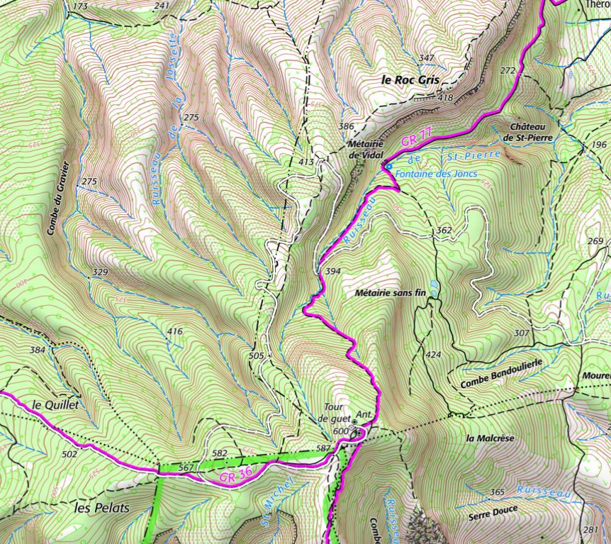 IGN un peu atténué (transparence réglable) et couche vecteur garmin 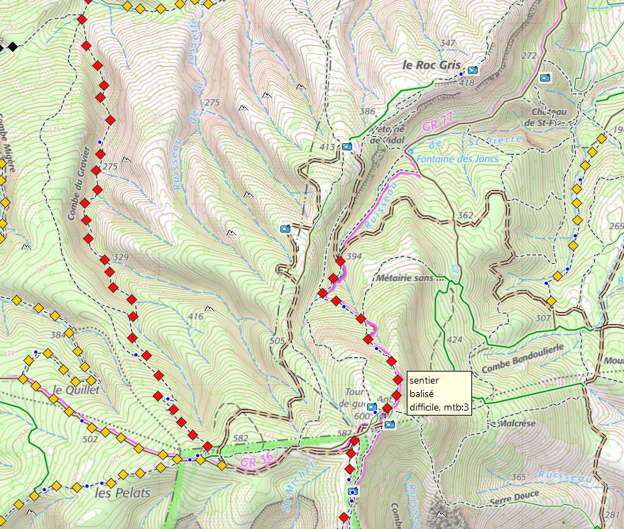 avec les données Alti de l'IGN  avec les photos de l'IGN et strava (bascule d'un clic dans l'interface) 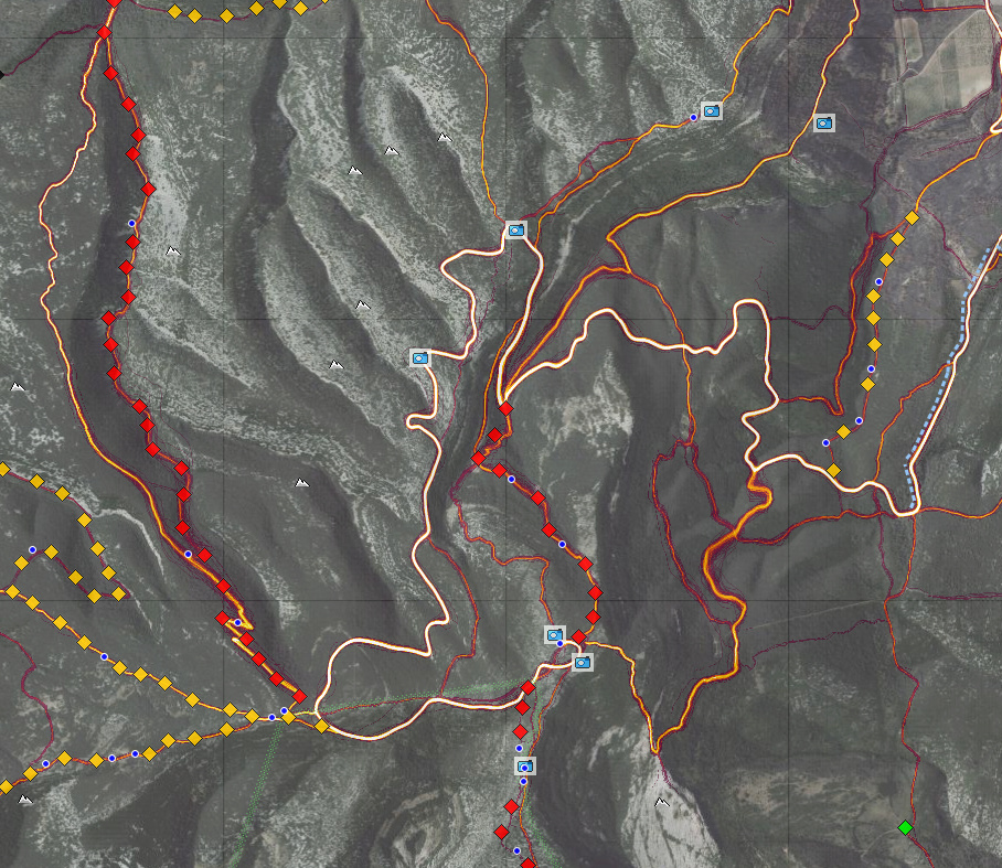 strava sur l'IGN estompé pour la lisibilité (réglage dans l'interface)  le cadastre aux derniers niveaux de zoom (30 et 10 m) 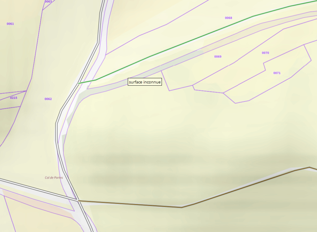 la couche vecteur garmin avec ici les forêts domaniales 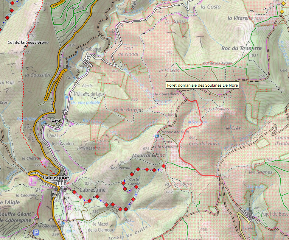 un petit calcul d'itinéraire ici en mode vélo court (pour l'enduro)  le même en cyclomoteur pour le "trail" 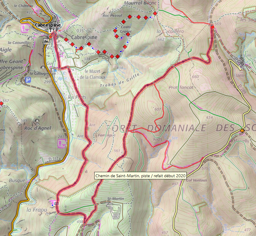 |
|
  | |
Contenu sponsorisé
 |  Sujet: Re: QmapShack une alternative à Basecamp Sujet: Re: QmapShack une alternative à Basecamp  | |
| |
|
  | |
|